
Braemar Park Master Plan Implementation
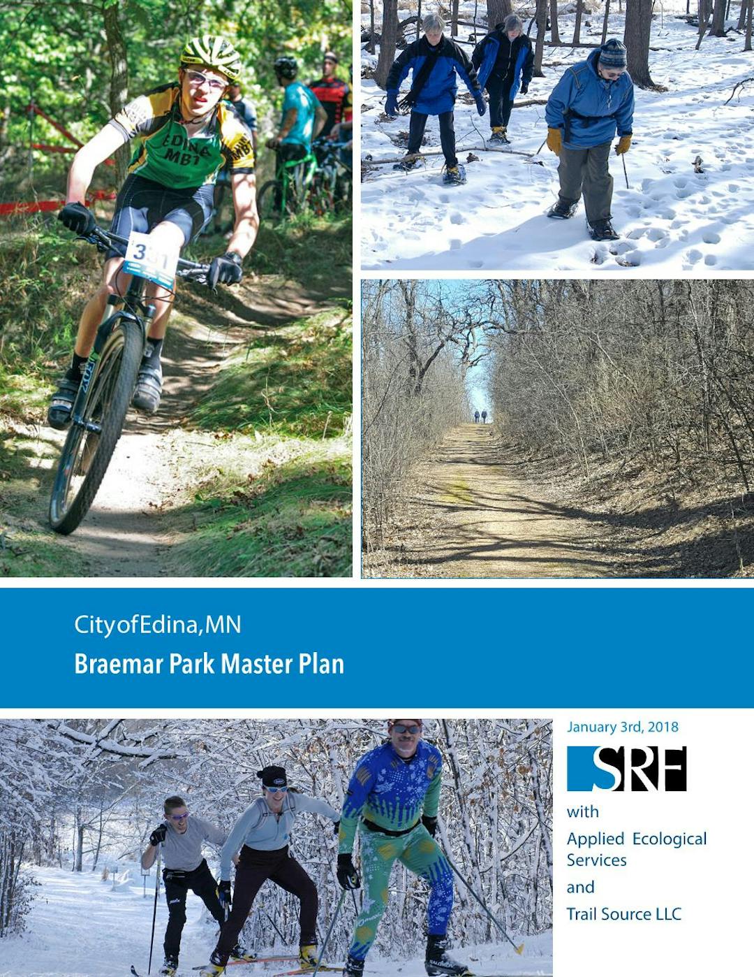
The Braemar Park master plan was created in 2017 with the help of residents and community members. City Council approved the master plan on Jan. 3, 2018. On Nov. 8, 2022, voters approved via referendum a local option sales tax to allocate $8.1 million of project funding for implementation and next phases of the Braemar Park master plan. Project planning efforts are moving forward for completing final design and constructing improvements in the park. Additional stakeholder and public engagement will occur during preliminary and final design to integrate comment and feedback into the design process.
Current proposed trail and park improvements include:
- Walking trails
- Mountain bike trails
- Cross-country skiing trails
- Pickleball
- Courtney Fields baseball complex improvements
- Wayfinding signs and trail connections
- Natural resource restoration
- Improved parking and access to Braemar Golf Course, Braemar Arena, and Courtney Fields
Question and Answers
Staff and Consultants will do our best to answer any questions you may have about project process, progress, and features.
-
Share Any updates on when / where the pickleball location will be? on Facebook Share Any updates on when / where the pickleball location will be? on X (formerly Twitter) Share Any updates on when / where the pickleball location will be? on Linkedin Email Any updates on when / where the pickleball location will be? link
Any updates on when / where the pickleball location will be?
crfleck asked 11 months agoWe are working through design finalization for a pickleball practice facility in conjunction with a parking lot expansion at the Braemar Golf Dome. This would provide 4 seasonal courts on pickleball tournament surfacing. The area would be designated and set up for pickleball usage May-October each season and parking would be available onsite. Finalized plans will be posted when approvals have been completed. Construction is anticipated to start the summer of 2026 pending approvals.
-
Share Will cross country skiing be available this winter 2025-26? on Facebook Share Will cross country skiing be available this winter 2025-26? on X (formerly Twitter) Share Will cross country skiing be available this winter 2025-26? on Linkedin Email Will cross country skiing be available this winter 2025-26? link
Will cross country skiing be available this winter 2025-26?
Laurine asked 7 months agoWe are holding on to our optimism that we will be able to groom trails for 2025-26. Equipment is ready and waiting for the required 8" snow cover in order to protect turf and make sustainable trails. We will update with trail layouts as soon as equipment lays tracks.
-
Share has a design for the playground been selected yet? Will be get to weigh in? on Facebook Share has a design for the playground been selected yet? Will be get to weigh in? on X (formerly Twitter) Share has a design for the playground been selected yet? Will be get to weigh in? on Linkedin Email has a design for the playground been selected yet? Will be get to weigh in? link
has a design for the playground been selected yet? Will be get to weigh in?
Marlee asked over 1 year agoMarlee,
Apologies for delayed response. We are sorry we missed your feedback during our engagement surveys. We engaged with two surveys last summer to select features, colors, and overall layout. The community voted and Northland Recreation and Little Tykes was the chosen design. This playground started installation last fall and will be opened in May after the safety surfacing and final inspections are completed.
Thank you for your question,
Rachel Finberg
Park Planning Project Manager
-
Share I have now walked the entirety of the new walking trail around the perimeter of the park as well as the hill spur on the east side. There are some areas where the signage indicating the location of the walking trail needs to be improved. I had to walk around some of the intersections to find out where the trail continued. Also maybe add more signage at the start of the walking trail on the east end. I’ve seen tire treads on the path there which leads me to believe folks are missing the trail indicators. on Facebook Share I have now walked the entirety of the new walking trail around the perimeter of the park as well as the hill spur on the east side. There are some areas where the signage indicating the location of the walking trail needs to be improved. I had to walk around some of the intersections to find out where the trail continued. Also maybe add more signage at the start of the walking trail on the east end. I’ve seen tire treads on the path there which leads me to believe folks are missing the trail indicators. on X (formerly Twitter) Share I have now walked the entirety of the new walking trail around the perimeter of the park as well as the hill spur on the east side. There are some areas where the signage indicating the location of the walking trail needs to be improved. I had to walk around some of the intersections to find out where the trail continued. Also maybe add more signage at the start of the walking trail on the east end. I’ve seen tire treads on the path there which leads me to believe folks are missing the trail indicators. on Linkedin Email I have now walked the entirety of the new walking trail around the perimeter of the park as well as the hill spur on the east side. There are some areas where the signage indicating the location of the walking trail needs to be improved. I had to walk around some of the intersections to find out where the trail continued. Also maybe add more signage at the start of the walking trail on the east end. I’ve seen tire treads on the path there which leads me to believe folks are missing the trail indicators. link
I have now walked the entirety of the new walking trail around the perimeter of the park as well as the hill spur on the east side. There are some areas where the signage indicating the location of the walking trail needs to be improved. I had to walk around some of the intersections to find out where the trail continued. Also maybe add more signage at the start of the walking trail on the east end. I’ve seen tire treads on the path there which leads me to believe folks are missing the trail indicators.
JennyC asked almost 2 years agoStaff, consultants, and MORC are working on identifying additional signage needs. Additional indicator signs and permanent trail signs will be added in 2025 to help users navigate trail system.
Rachel Finberg
Park Planner
-
Share Hi, Love the new trails! Is there a place where you post updates if the trails are closed? Yesterday and today the South East trail has been closed. Is it closed for the season or just maintenance? Thanks Bret on Facebook Share Hi, Love the new trails! Is there a place where you post updates if the trails are closed? Yesterday and today the South East trail has been closed. Is it closed for the season or just maintenance? Thanks Bret on X (formerly Twitter) Share Hi, Love the new trails! Is there a place where you post updates if the trails are closed? Yesterday and today the South East trail has been closed. Is it closed for the season or just maintenance? Thanks Bret on Linkedin Email Hi, Love the new trails! Is there a place where you post updates if the trails are closed? Yesterday and today the South East trail has been closed. Is it closed for the season or just maintenance? Thanks Bret link
Hi, Love the new trails! Is there a place where you post updates if the trails are closed? Yesterday and today the South East trail has been closed. Is it closed for the season or just maintenance? Thanks Bret
Bret K asked over 1 year agoBret,
Trail closures can be seen on Trailbot app or MORC website. Closures are typically due to weather conditions or contractors working in the area.
Rachel Finberg
Park Planner
-
Share Just curious, is the playground at Courtney field still going in near the existing shed, or is it going now where the rebar is being placed? Love what you are doing, it’s all looking great. on Facebook Share Just curious, is the playground at Courtney field still going in near the existing shed, or is it going now where the rebar is being placed? Love what you are doing, it’s all looking great. on X (formerly Twitter) Share Just curious, is the playground at Courtney field still going in near the existing shed, or is it going now where the rebar is being placed? Love what you are doing, it’s all looking great. on Linkedin Email Just curious, is the playground at Courtney field still going in near the existing shed, or is it going now where the rebar is being placed? Love what you are doing, it’s all looking great. link
Just curious, is the playground at Courtney field still going in near the existing shed, or is it going now where the rebar is being placed? Love what you are doing, it’s all looking great.
KariJ asked about 2 years agoPlayground will be located where existing batting cages are. The rebar location will be the new batting cages. We wanted to place the playground close to neighborhood connections and trail system.
Rachel Finberg
Park Planner
-
Share How do we know if the Braemar mtb trails are open or closed? Packing up and driving there only to find the gates closed is frustrating. on Facebook Share How do we know if the Braemar mtb trails are open or closed? Packing up and driving there only to find the gates closed is frustrating. on X (formerly Twitter) Share How do we know if the Braemar mtb trails are open or closed? Packing up and driving there only to find the gates closed is frustrating. on Linkedin Email How do we know if the Braemar mtb trails are open or closed? Packing up and driving there only to find the gates closed is frustrating. link
How do we know if the Braemar mtb trails are open or closed? Packing up and driving there only to find the gates closed is frustrating.
DavidW asked almost 2 years agoTrail status can be viewed on the Trailbot app. We also are trying to update the project site with closures.
Rachel Finberg Park Planner
-
Share I have three questions with regard to the Braemar Park implementation of the walking, biking and X-country ski areas: 1. Will a new map be made showing all the bike paths and walking trails as they actually have been constructed, i.e. photos from a drone camera--with clearly marked bike trails--where they begin to the end? 2. Will those trails also be clearly marked on the ground in the nature areas, e.g. the hills east of Braemar Golf Course 3. I have stumbled on barbed wire several times--among the trails and wondered if the Pathfinder Trail Building company doing the current construction of bike and walking trails, would remove some old barbed wire--located in to the east and north of the Braemar Golf Course hills. I would be happy to talk to the crew and ask if they might do that. Thank you for listening to my concern, from a happy Edina resident and supporter of your department's foresight in transforming underused areas of Braemar Park! Cordially, David Bremer on Facebook Share I have three questions with regard to the Braemar Park implementation of the walking, biking and X-country ski areas: 1. Will a new map be made showing all the bike paths and walking trails as they actually have been constructed, i.e. photos from a drone camera--with clearly marked bike trails--where they begin to the end? 2. Will those trails also be clearly marked on the ground in the nature areas, e.g. the hills east of Braemar Golf Course 3. I have stumbled on barbed wire several times--among the trails and wondered if the Pathfinder Trail Building company doing the current construction of bike and walking trails, would remove some old barbed wire--located in to the east and north of the Braemar Golf Course hills. I would be happy to talk to the crew and ask if they might do that. Thank you for listening to my concern, from a happy Edina resident and supporter of your department's foresight in transforming underused areas of Braemar Park! Cordially, David Bremer on X (formerly Twitter) Share I have three questions with regard to the Braemar Park implementation of the walking, biking and X-country ski areas: 1. Will a new map be made showing all the bike paths and walking trails as they actually have been constructed, i.e. photos from a drone camera--with clearly marked bike trails--where they begin to the end? 2. Will those trails also be clearly marked on the ground in the nature areas, e.g. the hills east of Braemar Golf Course 3. I have stumbled on barbed wire several times--among the trails and wondered if the Pathfinder Trail Building company doing the current construction of bike and walking trails, would remove some old barbed wire--located in to the east and north of the Braemar Golf Course hills. I would be happy to talk to the crew and ask if they might do that. Thank you for listening to my concern, from a happy Edina resident and supporter of your department's foresight in transforming underused areas of Braemar Park! Cordially, David Bremer on Linkedin Email I have three questions with regard to the Braemar Park implementation of the walking, biking and X-country ski areas: 1. Will a new map be made showing all the bike paths and walking trails as they actually have been constructed, i.e. photos from a drone camera--with clearly marked bike trails--where they begin to the end? 2. Will those trails also be clearly marked on the ground in the nature areas, e.g. the hills east of Braemar Golf Course 3. I have stumbled on barbed wire several times--among the trails and wondered if the Pathfinder Trail Building company doing the current construction of bike and walking trails, would remove some old barbed wire--located in to the east and north of the Braemar Golf Course hills. I would be happy to talk to the crew and ask if they might do that. Thank you for listening to my concern, from a happy Edina resident and supporter of your department's foresight in transforming underused areas of Braemar Park! Cordially, David Bremer link
I have three questions with regard to the Braemar Park implementation of the walking, biking and X-country ski areas: 1. Will a new map be made showing all the bike paths and walking trails as they actually have been constructed, i.e. photos from a drone camera--with clearly marked bike trails--where they begin to the end? 2. Will those trails also be clearly marked on the ground in the nature areas, e.g. the hills east of Braemar Golf Course 3. I have stumbled on barbed wire several times--among the trails and wondered if the Pathfinder Trail Building company doing the current construction of bike and walking trails, would remove some old barbed wire--located in to the east and north of the Braemar Golf Course hills. I would be happy to talk to the crew and ask if they might do that. Thank you for listening to my concern, from a happy Edina resident and supporter of your department's foresight in transforming underused areas of Braemar Park! Cordially, David Bremer
bremerda@comcast.net asked about 2 years agoDavid,
Thank you for your support and questions.
- The Braemar Trail system will include multiple wayfinding and signage types. Cross Country Ski Trails will be located primarily within the Golf course layout and will be dependent yearly on conditions and posted online and at trail entry points. Trailhead Parking as well as Hiking and Biking trail entry points will have larger trail map networks and close ups of trail sections. The trails themselves will be marked to delineate use (hiking/snowshoeing, or biking), difficulty level, and direction of travel (biking is one way). We did our best to keep trail crossings to a minimal, but caution signage will also be placed to alert users of an upcoming crossing or hazard. Once the trail network is completed (connector to the south and Hilary Lane/Braemar Blvd design) we will also place mile markers for reference.
- At this point trails will not be surfaced differently to delineate them from natural areas (no gravel or mulch). Paths will be mowed, and vegetation kept low for users. We will ask users to stay on trails to help us in the success of the landscape restoration project. Entry points and trail access will be limited to designated areas to better communicate important notices and trail information to users.
- Our trail builder has uncovered and come across numerous items and remnants of the past usage of these spaces. They have exposed and removed items when they come across them in construction but there is additional clean up needed. Volunteers and City staff will assist in the future maintenance of these spaces, but we would like to remove any items that create hazards. If you could reach out directly to help us locate these, contractors or city staff can work to remove or identify them before the trail systems opens for use.
Rachel Finberg
Park Planner
rfinberg@edinamn.gov
-
Share Any update on what and where the pickleball location will be? Havent seen any updates on details or timing around it since we completed the survey. on Facebook Share Any update on what and where the pickleball location will be? Havent seen any updates on details or timing around it since we completed the survey. on X (formerly Twitter) Share Any update on what and where the pickleball location will be? Havent seen any updates on details or timing around it since we completed the survey. on Linkedin Email Any update on what and where the pickleball location will be? Havent seen any updates on details or timing around it since we completed the survey. link
Any update on what and where the pickleball location will be? Havent seen any updates on details or timing around it since we completed the survey.
crfleck asked about 2 years agoThanks for the question. We have taken the survey results the community has supplied and used them to identify the needs for the location both playability and supporting amenities. A consultant is currently under contract to create preliminary designs for the pickleball courts in conjunction with other civil site projects. We are evaluating site conditions and impacts to confirm the location has minimal impacts and construction is within project budget. If designs fit project and community needs then construction would be summer of 2025.
Rachel Finberg
Park Planner
rfinberg@edinamn.gov
-
Share Can you communicate a rough estimate as to when the first phase of the MTB trails will open up? Thanks! on Facebook Share Can you communicate a rough estimate as to when the first phase of the MTB trails will open up? Thanks! on X (formerly Twitter) Share Can you communicate a rough estimate as to when the first phase of the MTB trails will open up? Thanks! on Linkedin Email Can you communicate a rough estimate as to when the first phase of the MTB trails will open up? Thanks! link
Can you communicate a rough estimate as to when the first phase of the MTB trails will open up? Thanks!
Ben D asked about 2 years agoTrails are currently being constructed and Pathfinder is making amazing progress. We had initially anticipated an October opening but are hoping to open segments up as they pass inspections. Our eastern segment has walking paths and blue trails and is projected to be open by July. Staff and contractors will need to evaluate trails and remove hazard trees so we ask the public to be patient and wait for official trail opening to maintain trail integrity and longevity. We will post segment openings with maps and imagery when they are ready for walkers and riders.
Rachel Finberg
Park Planner
Who's Listening
-
Director of Parks and Recreation

Email pvetter@edinamn.gov -
Assistant Director - Parks and Natural Resources
TSEmail tswenson@edinamn.gov -

Phone 9528260397 Email rdevries@edinamn.gov
Lifecycle
-
Community Engaged
Braemar Park Master Plan Implementation has finished this stage2017 City Staff, Stakeholders, and community members provided input and feedback to create a master plan for Braemar Park. See engagement log in documents for more information.
-
Master Plan Approved
Braemar Park Master Plan Implementation has finished this stageJanuary 3rd 2018, City Council approved Braemar Park Master Plan
-
Funding Identified
Braemar Park Master Plan Implementation has finished this stageNovember 2022 voters approved a referendum to allowed for local option sales tax revenue to be allocated to the implementation of Braemar Park master Plan.
-
Consultants hired and master plan concept designs are refined
Braemar Park Master Plan Implementation has finished this stageSpring 2023 consultants are hired to continue refining design concepts set forward in the approved master plan. Designer are engaged for Courtney Fields upgrades, trails, natural resources, and site improvements.
-
Community and Stakeholder Feedback
Braemar Park Master Plan Implementation has finished this stageAn open house for the community will be held September 6th from 4-7 at Braemar Backyard Rink. Staff and consultants will be on hand to answer questions and provide updates on project components. Feedback will also be collected about preliminary trail layouts and other master plan components. Feedback will also be collected on Better Together Edina.
-
Parks and Recreation Commission Review and Comment
Braemar Park Master Plan Implementation has finished this stageCommissioners will review and comment on preliminary trail layouts and concept design. Comments will be combined with community feedback and provided to City Council.
-
City Council 30% Design Update
Braemar Park Master Plan Implementation has finished this stageCity Council will receive a staff report and presentation of the refined Braemar Park master plan concepts. This will include Parks and Recreation Commissions comments as well as community feedback. Staff will present to City Council at a work session on October 17th, 2023
-
Natural Resources Restoration Phase 1
Braemar Park Master Plan Implementation has finished this stageBuckthorn and other target species removal was awarded to Landbridge Ecological for targeted areas. Future phases will include addition invasive removals, enhancements and plantings, and long term management.
-
Braemar Trails Enters Design Development
Braemar Park Master Plan Implementation has finished this stageBased on feedback collected from staff, stakeholders, community, commissioners, mayor and city council staff and consultants will progress into design development for the Braemar Trails project.
-
Braemar Trails Enters Construction Documents
Braemar Park Master Plan Implementation has finished this stage -
Braemar Trails Bid Packages are posted
Braemar Park Master Plan Implementation has finished this stage -
Biking and Hiking Trail Construction Begins
Braemar Park Master Plan Implementation has finished this stagePathfinder Trail Building has been awarded contract for trail building. The first phase of trails will be the eastern and western hillsides. The second phase will happen later this season or next and will include a shared trail boardwalk and connector through the south Braemar Park property by Nine Mile Creek.
-
Trails Open
Braemar Park Master Plan Implementation is currently at this stageHiking Trails and Biking Trails are Open!


Thank you for your contribution!
Help us reach out to more people in the community
Share this with family and friends