Morningside Flood Infrastructure Project
This project has been completed and this project page will no longer be updated. Please contact staff with any questions or comments. Thank you.

The Morningside Neighborhood has several low and landlocked areas prone to flooding. Climate change has already increased the risk of flooding and will continue to do so. This project helps the community be more resilient to flooding. Project benefits are balanced across the neighborhood and there is no increase in risk to any property.
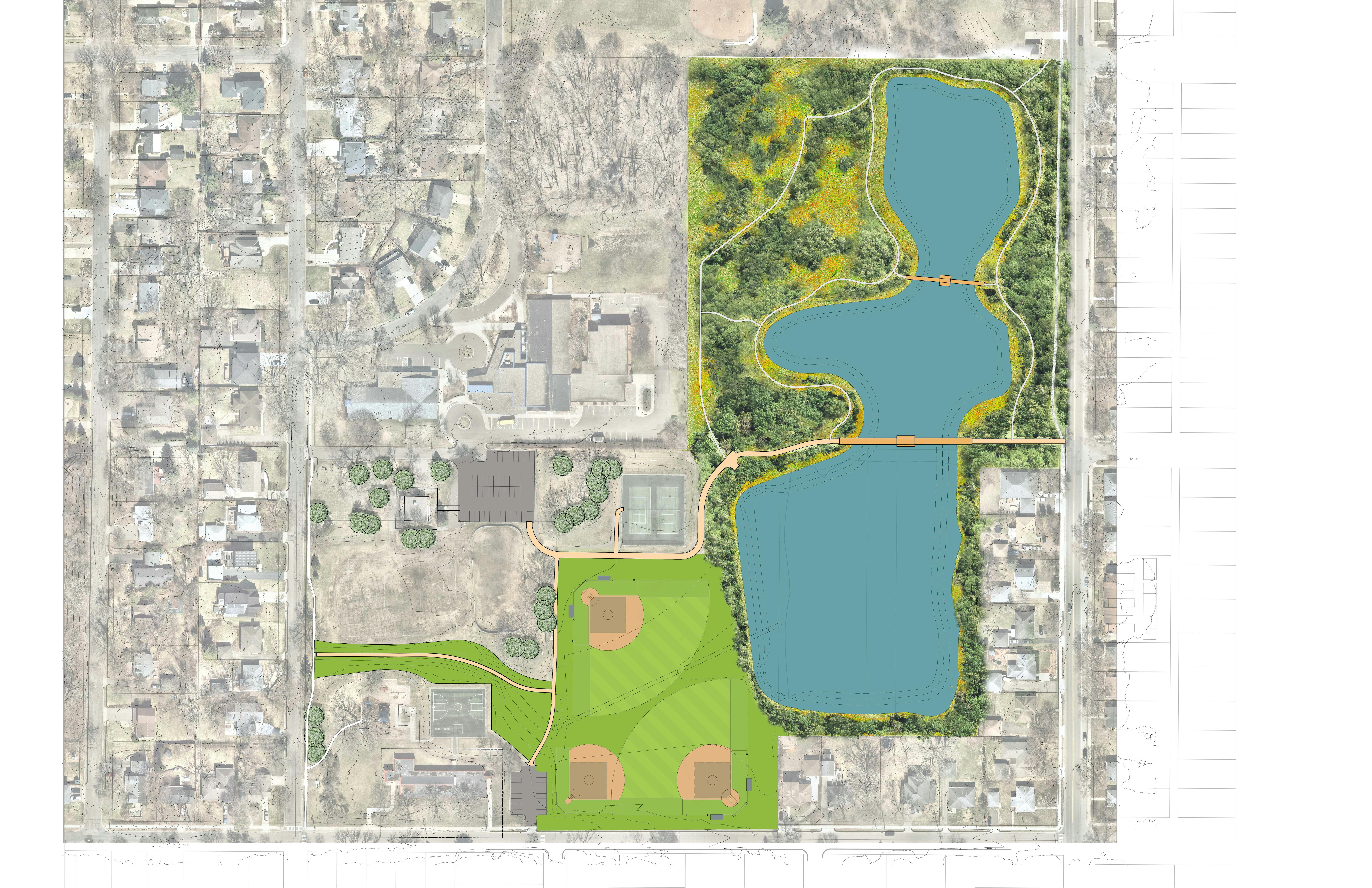
Ponds, pipes and a surface swale will be used to safely move and store floodwaters. An expanded pipe and swale will provide overflow from the Lynn/Kipling inundation area and the Grimes Avenue low point, and an expanded and reconfigured pipe network and minor grade changes will move water away from homes. Weber Pond and the Lynn/Kipling Pond will be expanded and lowered. About six acres of trees will be removed in Weber Woods to accommodate the larger ponds.
The flood infrastructure project also includes:
- Natural resources restoration in upland areas.
- Nature trails and bridge crossings at two locations at Weber Park.
- Improved pedestrian access to the park with some ADA-compliant paths in Weber Park.
- Rebuilt sports fields in impacted areas with new turf and irrigation systems.
The flood infrastructure project coincides with planned roadway reconstruction in the neighborhood in 2022 and 2023.
This project has been completed and this project page will no longer be updated. Please contact staff with any questions or comments. Thank you.
-
Weber Pond - Fall 2024
Share Weber Pond - Fall 2024 on Facebook Share Weber Pond - Fall 2024 on Twitter Share Weber Pond - Fall 2024 on Linkedin Email Weber Pond - Fall 2024 link
-
Natural areas management
Share Natural areas management on Facebook Share Natural areas management on Twitter Share Natural areas management on Linkedin Email Natural areas management linkThe establishment phase of the restored natural areas will continue through the end of 2025. Ecological restoration professionals will be on site several times throughout the growing season to manage invasive species and promote diverse, healthy vegetation. After the initial establishment phase ends, the restored acres will graduate into the long-term natural areas management program so we can continue to care for the land far into the future.
-
Thank you for joining us to celebrate!
Share Thank you for joining us to celebrate! on Facebook Share Thank you for joining us to celebrate! on Twitter Share Thank you for joining us to celebrate! on Linkedin Email Thank you for joining us to celebrate! linkWe held a ribbon cutting ceremony on July 11th to celebrate the project


-
Reminder - Ribbon Cutting Ceremony tomorrow, July 11th
Share Reminder - Ribbon Cutting Ceremony tomorrow, July 11th on Facebook Share Reminder - Ribbon Cutting Ceremony tomorrow, July 11th on Twitter Share Reminder - Ribbon Cutting Ceremony tomorrow, July 11th on Linkedin Email Reminder - Ribbon Cutting Ceremony tomorrow, July 11th linkThursday, July 11 from 5-6:30pm at Weber Park. Come and go when it works for you – no RSVP required!
-
How does it work?
Share How does it work? on Facebook Share How does it work? on Twitter Share How does it work? on Linkedin Email How does it work? linkWe've created a graphic to illustrate how the ponds, pipes, and swale work together to reduce flood exposure for more than 160 homes in the neighborhood. You can access a copy here or in the Documents section.
-
Grebe nesting on Weber Pond
Share Grebe nesting on Weber Pond on Facebook Share Grebe nesting on Weber Pond on Twitter Share Grebe nesting on Weber Pond on Linkedin Email Grebe nesting on Weber Pond linkA grebe has made her nest on Weber Pond.
-
Drone images from June 24
Share Drone images from June 24 on Facebook Share Drone images from June 24 on Twitter Share Drone images from June 24 on Linkedin Email Drone images from June 24 linkWeber Park looking toward Minneapolis
June 24, 2024Weber Park looking toward St Louis Park
June 24, 2024Lynn Ave and Kipling Ave Pond
June 24, 2024Swale through Weber Park with native blooms on south side of path
June 24, 2024 -
Native blooms at Lynn Kipling Pond
Share Native blooms at Lynn Kipling Pond on Facebook Share Native blooms at Lynn Kipling Pond on Twitter Share Native blooms at Lynn Kipling Pond on Linkedin Email Native blooms at Lynn Kipling Pond linkWe caught some native plants a couple weeks ago at Lynn Kipling Pond that are blooming or nearly blooming.
Partridge pea, black-eyed Susan, Canada milkvetch, meadow rue, soft stem bulrush, and purple coneflower.


-
You're Invited! Ribbon Cutting Ceremony - July 11
Share You're Invited! Ribbon Cutting Ceremony - July 11 on Facebook Share You're Invited! Ribbon Cutting Ceremony - July 11 on Twitter Share You're Invited! Ribbon Cutting Ceremony - July 11 on Linkedin Email You're Invited! Ribbon Cutting Ceremony - July 11 linkThursday, July 11 from 5-6:30pm at Weber Park
After years of planning and construction, it’s time to celebrate! We want to express our gratitude for your participation and patience during the Morningside Flood Infrastructure Project and the work done in Weber Park and at Lynn Avenue and Kipling Avenue Pond.
The community is now more resilient to flooding, and the park has new features like boardwalks, rebuilt nature trails and sports fields, and thousands of newly planted trees, shrubs, and native perennials.
Join us at the park to hear from Mayor Jim Hovland, explore project highlights and enjoy an ice cream treat. Come and go when it works for you – no RSVP required!
-
Spring Showers
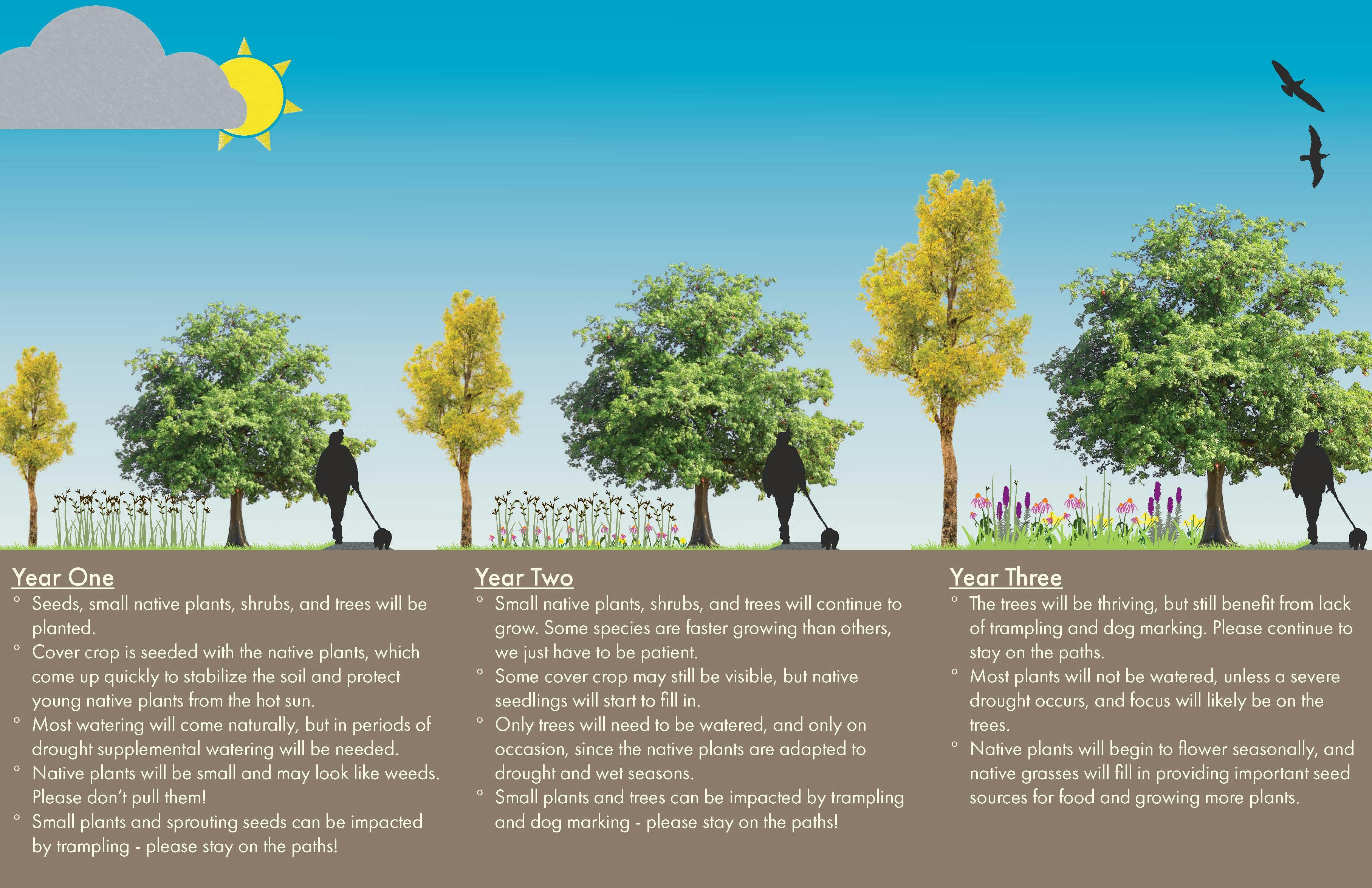
Share Spring Showers on Facebook Share Spring Showers on Twitter Share Spring Showers on Linkedin Email Spring Showers linkThe spring rains have brought some relief from the drought conditions we experienced last year. The plantings are enjoying the rain and we are pleased with how the trees are flushing out. The site is patchy and weedy with a few native species blooming which is typical of new natural areas in their establishment phase.
Natural areas take a few years to reach their full beauty. We see encouraging signs in year two. Thank you for your patience!
Who's Listening
-
Phone 952-903-5713 Email RBintner@EdinaMN.gov -
Phone 952-826-0445 Email JWilson@EdinaMN.gov -
Phone 952-826-0317 Email TSwenson@EdinaMN.gov
Key Dates
-
July 11 2024
-
October 19 2021
-
September 21 2021
Photos
Lifecycle
-
Share Information
Morningside Flood Infrastructure Project has finished this stageSummer 2020
Information about flood risk, Edina's Flood Risk Reduction Strategy, and actions people can take to reduce their own flood risk will be shared.
-
Present Initial Concepts
Morningside Flood Infrastructure Project has finished this stageFall 2020
Initial concepts will be presented for feedback.
-
Present Refined Concepts
Morningside Flood Infrastructure Project has finished this stageWinter 2020
Refined concepts based on feedback will be presented.
-
Make a Decision
Morningside Flood Infrastructure Project has finished this stageSpring 2021
Staff will make a recommendation and City Council will make a decision.
-
Close the Loop - Concept Design Phase
Morningside Flood Infrastructure Project has finished this stageSpring 2021
The decision will be communicated to the public and archived on the Better Together Edina project page.
-
Added: Detailed Engineering and Landscape Design Begins
Morningside Flood Infrastructure Project has finished this stageSpring 2021
City Council approved the project at their April 20th, 2021 meeting. This moved the project from the concept design phase to the detailed engineering and landscape design phase.
-
Added: Present Landscape Design
Morningside Flood Infrastructure Project has finished this stageSummer 2021
An initial version of the design (at 30% completion) will be presented for feedback.
-
Added: Make a Decision
Morningside Flood Infrastructure Project has finished this stageFall 2021
Staff will make a recommendation and City Council will make a decision.
-
Added: Design
Morningside Flood Infrastructure Project has finished this stageFall 2021 - Winter 2022
Staff will complete the design and prepare construction bid documents.
-
Added: Construction Phase 1
Morningside Flood Infrastructure Project has finished this stageWinter 2022
Tree removal.
-
Added: Construction Phase 2
Morningside Flood Infrastructure Project has finished this stageSpring 2022 - early Winter 2023
Grading and excavation to create flood storage.
Upstream pipe capacity work will occur as part of the street reconstruction projects in 2022 and 2023.
-
Added: Construction Phase 3 - Park Restoration
Morningside Flood Infrastructure Project is currently at this stageFall 2022 - Summer 2023
Turf restoration, natural resource restoration, and tree planting.
Related projects
Documents
-
 MFIP_Outcomes_How it works.pdf (9.18 MB) (pdf)
-
 MFIP_Outcomes_Boards.pdf (10.1 MB) (pdf)
-
 Weber Park Scavenger Hunt Map.pdf (2.71 MB) (pdf)
-
 Restoration Phase Graphic.pdf (5.39 MB) (pdf)
-
 2022_Morningside-Flood-Infrastructure_FAQs.pdf (353 KB) (pdf)
-
 Final park plan_Feb2022.pdf (6.81 MB) (pdf)
-
 Park Birds Eye View Feb2022.pdf (2.53 MB) (pdf)
-
 Pond boardwalk rendering Feb2022.pdf (1.75 MB) (pdf)
-
 Lynn Kipling Pond Plan_Feb2022.pdf (2.8 MB) (pdf)
-
 Edition Edina_Feb2022.pdf (1.95 MB) (pdf)
-
 Ecological Quality Assessment Report_2021.pdf (1.68 MB) (pdf)
-
 Morningside_Habitat_Plan.pdf (6.27 MB) (pdf)
-
 maps
maps
-
 concept development
-
 Edina's Flood Risk Reduction Strategy report (21.6 MB) (pdf)
-
 Public Participation Plan (177 KB) (pdf)
-
 Anticipated Project Timeline - as of June 3, 2020 (2.33 MB) (jpg)
-
 June 3, 2020 presentation (2.33 MB) (pdf)
-
 Survey 1 results.jpg (98.5 KB) (jpg)
-
 September 3, 2020 presentation (10.4 MB) (pdf)
-
 Morningside_Flood_Infrastructure_Technical_Memo_Oct2020.pdf (10.7 MB) (pdf)
-
 Infrastructure Scenarios_Oct2020.pdf (12.4 MB) (pdf)
-
 December 9, 2020 presentation (3.2 MB) (pdf)
-
 Engagement Report_January 2021 (17.3 MB) (pdf)
-
 Technical_Memo_Feb2021.pdf (7.04 MB) (pdf)
-
 DRAFT Preliminary Report_March 16 Work Session.pdf (1.92 MB) (pdf)
-
 FINALIZED Preliminary Report_March 16 Work Session.pdf (1.79 MB) (pdf)
-
 Staff Report_April 20 2021 (793 KB) (pdf)
-
-
 30% design
-
 Eng&Landscape Design Public Participation Plan (167 KB) (pdf)
-
 Morningside 30%Plan.pdf (4.82 MB) (pdf)
-
 Morningside 30%Imagery.pdf (5.35 MB) (pdf)
-
 Morningside 30%Timeline_LK.pdf (3.71 MB) (pdf)
-
 Sept 21, 2021 City Council Presentation.pdf (6.1 MB) (pdf)
-
 Sept 21, 2021 Staff Report.pdf (318 KB) (pdf)
-
 Revised Morningside 30%Plan.pdf (13.7 MB) (pdf)
-
 Stakeholder Engagement Report_Oct2021 (610 KB) (pdf)
-
 Stakeholder Engagement Report_Appendix (1.63 MB) (pdf)
-
Videos
-
Click here to play video Weber Park Ribbon Cutting Reel Weber Park Ribbon Cutting Ceremony, July 11 , 2024
-
 Click here to play video
Morningside Project (starts at 3 min mark) 30% approval summary
Morningside Project (starts at 3 min mark) 30% approval summary
-
 Click here to play video
Flood Risk in the Morningside Neighborhood - a closer look
A closer look at the flooding problems in the Morningside Neighborhood.
-
 Click here to play video
Flood Risk in the Morningside Neighborhood
An overview of how and where flooding happens.


