Morningside Flood Infrastructure Project
This project has been completed and this project page will no longer be updated. Please contact staff with any questions or comments. Thank you.

The Morningside Neighborhood has several low and landlocked areas prone to flooding. Climate change has already increased the risk of flooding and will continue to do so. This project helps the community be more resilient to flooding. Project benefits are balanced across the neighborhood and there is no increase in risk to any property.
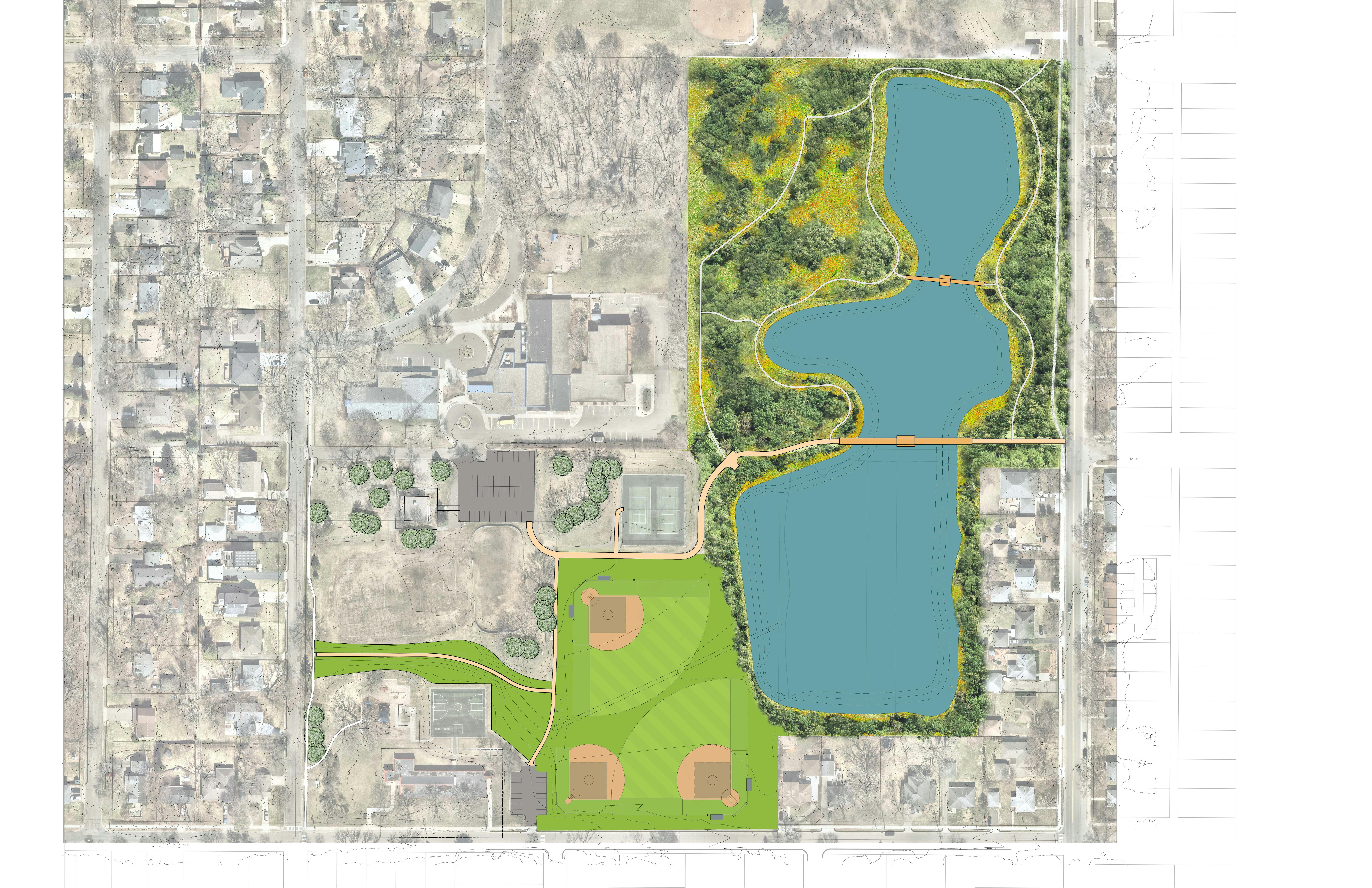
Ponds, pipes and a surface swale will be used to safely move and store floodwaters. An expanded pipe and swale will provide overflow from the Lynn/Kipling inundation area and the Grimes Avenue low point, and an expanded and reconfigured pipe network and minor grade changes will move water away from homes. Weber Pond and the Lynn/Kipling Pond will be expanded and lowered. About six acres of trees will be removed in Weber Woods to accommodate the larger ponds.
The flood infrastructure project also includes:
- Natural resources restoration in upland areas.
- Nature trails and bridge crossings at two locations at Weber Park.
- Improved pedestrian access to the park with some ADA-compliant paths in Weber Park.
- Rebuilt sports fields in impacted areas with new turf and irrigation systems.
The flood infrastructure project coincides with planned roadway reconstruction in the neighborhood in 2022 and 2023.
This project has been completed and this project page will no longer be updated. Please contact staff with any questions or comments. Thank you.
-
January Update
Share January Update on Facebook Share January Update on Twitter Share January Update on Linkedin Email January Update linkIf you missed the December meeting where we shared the refined concept design, you can watch a recording or review the presentation slides.
What we're working on now:
- Finalizing the technical engineering memo (January)
- Presenting to the Energy & Environment Commission (January)
- Presenting to the Planning Commission (January or February)
- Finalizing the engagement report (February)
- Drafting the staff recommendation to share with the City Council (now through March)
If you have any concerns, comments, and/or ideas, we want to hear them!
-
Reminder - Virtual Meeting #3 starts tomorrow
Share Reminder - Virtual Meeting #3 starts tomorrow on Facebook Share Reminder - Virtual Meeting #3 starts tomorrow on Twitter Share Reminder - Virtual Meeting #3 starts tomorrow on Linkedin Email Reminder - Virtual Meeting #3 starts tomorrow linkJoin us 5-6:30 p.m. on December 9th to hear about the new revised concept, ask questions, and give us your reaction. The livestream video link will be available under the 'Virtual Meetings' tab.
A recording of the video and a copy of the presentation will be posted after the meeting.
-
Virtual Meeting #3 - December 9
Share Virtual Meeting #3 - December 9 on Facebook Share Virtual Meeting #3 - December 9 on Twitter Share Virtual Meeting #3 - December 9 on Linkedin Email Virtual Meeting #3 - December 9 linkThe City will host a third virtual public meeting with residents from 5-6:30 p.m. on December 9th.
We've come up with a new revised concept that maximizes the flood risk reduction benefit.
Join us to learn more and tell us what you think.
-
Scenarios - Reactions and Ideas
Share Scenarios - Reactions and Ideas on Facebook Share Scenarios - Reactions and Ideas on Twitter Share Scenarios - Reactions and Ideas on Linkedin Email Scenarios - Reactions and Ideas linkProvide your reactions and ideas for the flood infrastructure scenarios under the Ideas tab. We'll use what we learn from you to come up with a single preferred option that we'll share with you at Virtual Meeting #3 on December 9th.
-
Reminder - Halloween Pop-up in Weber Park
Share Reminder - Halloween Pop-up in Weber Park on Facebook Share Reminder - Halloween Pop-up in Weber Park on Twitter Share Reminder - Halloween Pop-up in Weber Park on Linkedin Email Reminder - Halloween Pop-up in Weber Park linkJoin us to review alternatives, share your opinions, and get answers to your questions.
1-3 p.m. Saturday, October 31.
Or, you can take the virtual tour here.
-
Overview of Infrastructure Scenarios Now Available
Share Overview of Infrastructure Scenarios Now Available on Facebook Share Overview of Infrastructure Scenarios Now Available on Twitter Share Overview of Infrastructure Scenarios Now Available on Linkedin Email Overview of Infrastructure Scenarios Now Available linkWhat is the problem?
- "What is My Flood Risk?" interactive map - explore the risk for a specific property as well as across the neighborhood.
- Flood Risk Reduction Project video (3 mins) - introduction to the general flooding problem and what the project is about.
Flood Risk Reduction Project video #2 (5 mins) - a closer look at the flooding issues.
What options are being considered?
- Download an overview of the scenarios we've explored. If you're looking for a deep-dive into the material, you can read the technical memo that the overview is based on.
How do I participate?
- Join us for a socially distanced Halloween pop-up in Weber Park from 1-3 p.m. to review the scenarios and talk with staff.
- Share your reactions and ideas on the Ideas Tab.
- Call or email a staff person.
-
VIDEO: Flood Risk in the Morningside Neighborhood - A Closer Look
Share VIDEO: Flood Risk in the Morningside Neighborhood - A Closer Look on Facebook Share VIDEO: Flood Risk in the Morningside Neighborhood - A Closer Look on Twitter Share VIDEO: Flood Risk in the Morningside Neighborhood - A Closer Look on Linkedin Email VIDEO: Flood Risk in the Morningside Neighborhood - A Closer Look link -
Halloween Pop-up in Weber Park
Share Halloween Pop-up in Weber Park on Facebook Share Halloween Pop-up in Weber Park on Twitter Share Halloween Pop-up in Weber Park on Linkedin Email Halloween Pop-up in Weber Park linkJoin us to learn more about alternatives for reducing flood risk, share your opinions, and get answers to your questions. Oh, and candy.
1-3 p.m. Saturday, October 31
-
Landlocked Basins
Share Landlocked Basins on Facebook Share Landlocked Basins on Twitter Share Landlocked Basins on Linkedin Email Landlocked Basins linkLandlocked basins do not have low level outlets; the only way for water to leave is through evaporation, infiltration, transpiration, and/or pumping. Because there is no outlet structure, landlocked basins are prone to high water levels during wet years and can hold water long after a storm ends.
When making decisions about adding storm sewer outlets to these basins, we must consider downstream impacts and the trade-offs of transferring flood risk. We use 2-dimensional stormwater models to test infrastructure options so that we can understand how flood exposure changes, where the benefits accrue, and where and when options cause impacts.
This map shows landlocked basins and areas that drain to landlocked basins in the neighborhood.
-
County Ditch 17
Share County Ditch 17 on Facebook Share County Ditch 17 on Twitter Share County Ditch 17 on Linkedin Email County Ditch 17 linkBefore it was developed as a residential neighborhood in the mid-1900s, the Morningside neighborhood was largely a low-lying wet area, with a county ditch running right through it. The original plan for County Ditch 17 was part of the Minnesota History Museum collection from the bygone Hennepin County Soil and Water Conservation District. The Minnehaha Creek Watershed District is the current county ditch authority.
Here's a photo of the original plan and a modern map with the former ditch location drawn in. This 1908 survey map with modern streets overlaid shows the location of historical wetlands throughout the City.
Who's Listening
-
Phone 952-903-5713 Email RBintner@EdinaMN.gov -
Phone 952-826-0445 Email JWilson@EdinaMN.gov -
Phone 952-826-0317 Email TSwenson@EdinaMN.gov
Key Dates
-
July 11 2024
-
October 19 2021
-
September 21 2021
Photos
Lifecycle
-
Share Information
Morningside Flood Infrastructure Project has finished this stageSummer 2020
Information about flood risk, Edina's Flood Risk Reduction Strategy, and actions people can take to reduce their own flood risk will be shared.
-
Present Initial Concepts
Morningside Flood Infrastructure Project has finished this stageFall 2020
Initial concepts will be presented for feedback.
-
Present Refined Concepts
Morningside Flood Infrastructure Project has finished this stageWinter 2020
Refined concepts based on feedback will be presented.
-
Make a Decision
Morningside Flood Infrastructure Project has finished this stageSpring 2021
Staff will make a recommendation and City Council will make a decision.
-
Close the Loop - Concept Design Phase
Morningside Flood Infrastructure Project has finished this stageSpring 2021
The decision will be communicated to the public and archived on the Better Together Edina project page.
-
Added: Detailed Engineering and Landscape Design Begins
Morningside Flood Infrastructure Project has finished this stageSpring 2021
City Council approved the project at their April 20th, 2021 meeting. This moved the project from the concept design phase to the detailed engineering and landscape design phase.
-
Added: Present Landscape Design
Morningside Flood Infrastructure Project has finished this stageSummer 2021
An initial version of the design (at 30% completion) will be presented for feedback.
-
Added: Make a Decision
Morningside Flood Infrastructure Project has finished this stageFall 2021
Staff will make a recommendation and City Council will make a decision.
-
Added: Design
Morningside Flood Infrastructure Project has finished this stageFall 2021 - Winter 2022
Staff will complete the design and prepare construction bid documents.
-
Added: Construction Phase 1
Morningside Flood Infrastructure Project has finished this stageWinter 2022
Tree removal.
-
Added: Construction Phase 2
Morningside Flood Infrastructure Project has finished this stageSpring 2022 - early Winter 2023
Grading and excavation to create flood storage.
Upstream pipe capacity work will occur as part of the street reconstruction projects in 2022 and 2023.
-
Added: Construction Phase 3 - Park Restoration
Morningside Flood Infrastructure Project is currently at this stageFall 2022 - Summer 2023
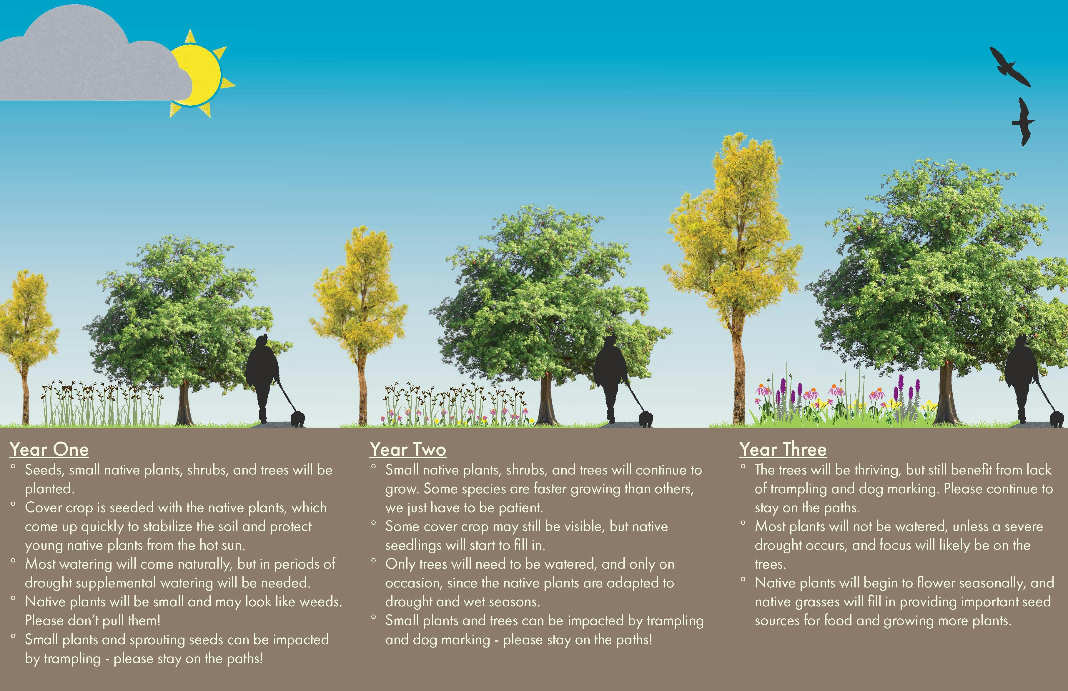
Turf restoration, natural resource restoration, and tree planting.
Related projects
Documents
-
 MFIP_Outcomes_How it works.pdf (9.18 MB) (pdf)
-
 MFIP_Outcomes_Boards.pdf (10.1 MB) (pdf)
-
 Weber Park Scavenger Hunt Map.pdf (2.71 MB) (pdf)
-
 Restoration Phase Graphic.pdf (5.39 MB) (pdf)
-
 2022_Morningside-Flood-Infrastructure_FAQs.pdf (353 KB) (pdf)
-
 Final park plan_Feb2022.pdf (6.81 MB) (pdf)
-
 Park Birds Eye View Feb2022.pdf (2.53 MB) (pdf)
-
 Pond boardwalk rendering Feb2022.pdf (1.75 MB) (pdf)
-
 Lynn Kipling Pond Plan_Feb2022.pdf (2.8 MB) (pdf)
-
 Edition Edina_Feb2022.pdf (1.95 MB) (pdf)
-
 Ecological Quality Assessment Report_2021.pdf (1.68 MB) (pdf)
-
 Morningside_Habitat_Plan.pdf (6.27 MB) (pdf)
-
 maps
maps
-
 concept development
-
 Edina's Flood Risk Reduction Strategy report (21.6 MB) (pdf)
-
 Public Participation Plan (177 KB) (pdf)
-
 Anticipated Project Timeline - as of June 3, 2020 (2.33 MB) (jpg)
-
 June 3, 2020 presentation (2.33 MB) (pdf)
-
 Survey 1 results.jpg (98.5 KB) (jpg)
-
 September 3, 2020 presentation (10.4 MB) (pdf)
-
 Morningside_Flood_Infrastructure_Technical_Memo_Oct2020.pdf (10.7 MB) (pdf)
-
 Infrastructure Scenarios_Oct2020.pdf (12.4 MB) (pdf)
-
 December 9, 2020 presentation (3.2 MB) (pdf)
-
 Engagement Report_January 2021 (17.3 MB) (pdf)
-
 Technical_Memo_Feb2021.pdf (7.04 MB) (pdf)
-
 DRAFT Preliminary Report_March 16 Work Session.pdf (1.92 MB) (pdf)
-
 FINALIZED Preliminary Report_March 16 Work Session.pdf (1.79 MB) (pdf)
-
 Staff Report_April 20 2021 (793 KB) (pdf)
-
-
 30% design
-
 Eng&Landscape Design Public Participation Plan (167 KB) (pdf)
-
 Morningside 30%Plan.pdf (4.82 MB) (pdf)
-
 Morningside 30%Imagery.pdf (5.35 MB) (pdf)
-
 Morningside 30%Timeline_LK.pdf (3.71 MB) (pdf)
-
 Sept 21, 2021 City Council Presentation.pdf (6.1 MB) (pdf)
-
 Sept 21, 2021 Staff Report.pdf (318 KB) (pdf)
-
 Revised Morningside 30%Plan.pdf (13.7 MB) (pdf)
-
 Stakeholder Engagement Report_Oct2021 (610 KB) (pdf)
-
 Stakeholder Engagement Report_Appendix (1.63 MB) (pdf)
-
Videos
-
Click here to play video Weber Park Ribbon Cutting Reel Weber Park Ribbon Cutting Ceremony, July 11 , 2024
-
 Click here to play video
Morningside Project (starts at 3 min mark) 30% approval summary
Morningside Project (starts at 3 min mark) 30% approval summary
-
 Click here to play video
Flood Risk in the Morningside Neighborhood - a closer look
A closer look at the flooding problems in the Morningside Neighborhood.
-
 Click here to play video
Flood Risk in the Morningside Neighborhood
An overview of how and where flooding happens.


